

What was the Original Community Plan?
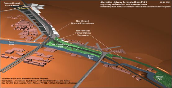
Local residents recognized the need to create safe and efficient truck access to Hunts Point’s industrial areas – indeed, the existing road system dumps trucks onto local streets, where they kill and injure local residents every year. Together, we challenged the NYSDOT assumption that truck access could only be created by sacrificing access to the waterfront. Since 1999, our organizations have worked together to design a more economically and ecologically sensible solution to local traffic and land use problems associated with the Sheridan Expressway.
The Community Plan that was created consisted of three major elements:
- Providing access from the Bruckner Expressway to Hunts Point at Leggett Avenue First, building new access ramps (both East and Westbound on- and off-ramps) from the Bruckner Expressway into and out of Hunts Point at Leggett Avenue would provide efficient truck access into the Hunts Point Market, the Fulton Fish Market and other industrial uses on the peninsula. Access at Leggett Avenue would better serve drivers coming from and going to Manhattan, Queens, and Brooklyn than NYSDOT’s proposal, which forces drivers to use the desperately congested Cross Bronx Expressway. Bringing trucks onto the peninsula at Leggett Avenue would also keep traffic away from the residential area and the waterfront.
- Removing the Sheridan: Second, placing a new interchange at Leggett Avenue would allow for the removal of the underutilized Sheridan Expressway, since trucks would now have a direct access to Hunts Point via the Bruckner Expressway. The removal (or, demapping) of the Sheridan would open up 28 acres of open space for new uses including open space and housing. This land would be close to the subway, the new parks, and the river waterfront. According to our plan, there would be room for 1,200 units of affordable housing, 200,000 square feet of commerical and community space, and the possibility for 700+ new jobs. And because the land would be publicly owned, new housing would remain permanently affordable so that the residents of the South Bronx could remain in the community that they are working to transform. The new community on the Sheridan would unite previously isolated neighborhoods of the South Bronx, and offer a better quality of life for the area.
- Elevating portions of the Bruckner to improve safety Third, our plan would elevate the Bruckner Expressway between Hunts Point Avenue and the east bank of the Bronx River. This stretch of the Bruckner is currently at street-level and provides little pedestrian access out of and into Hunts Point. The removal of the Sheridan and the elevation of the Bruckner would get rid of congestion and pedestrian danger zones such as the one at Hunts Point Ave. and Bruckner Blvd. The local streets that are disconnected because of the street-level Brucker would be reconnected; creating safe pedestrian/bike routes in and out of Hunts Point. Retail on Westchester Ave. would be able to expand across the river, and there would be space for new bike/pedestrian lanes across the river leading to the new Concrete Plant Park.
Oak Point Ramps and Plan 1E
In June 2008, NYSDOT announced that it had abandoned their plan to expand the Sheridan because it was physically impossible (something SBRWA had been telling them for years). It announced it was studying two final alternatives for the Bruckner-Sheridan Interchange: 1E, a variation of the Community Plan that takes down the Sheridan, and 2E, which keeps the Sheridan. Both plans included a new set of ramps at Oak Point fright yard. Because Plan 1E is a better version of our original Community Plan and allows for the Sheridan lands to be developed for the South Bronx community, SBRWA has decided to support Plan 1E.
Plan Components
If 1E is selected and the blueprint created by the New Community on the Sheridan Plan is adopted, we have the unbelievable opportunity to create a completely new community. The Sheridan land is currently free of any utilities, buildings, and families. Tearing down the Sheridan would open up 28 totally vacant acres of land without any displacement. Vacant land is nearly impossible to find in New York City, and an opportunity like that in the South Bronx is a once in a lifetime chance to build a new, state-of-the-art Green development.
LOCATION, LOCATION, LOCATION
The Sheridan site is a rare opportunity to build dense housing and commercial/community development in a location that takes advantage of public transportation and the Bronx River. Because the area around the Sheridan is already served by bus and train lines, new transportation lines do not have to be built and car-dependency is reduced. Building around pre-existing transportation is called “smart growth” and the New Community on the Sheridan is a perfect example of smart growth.
- The New Community will also be connected to the Bronx River Greenway and the South Bronx Greenway, making bicycling around the community easy and safe.
- The Sheridan lands are also very close to the Southern Blvd. shopping area. This district, and the new businesses that will be part of the New Community, mean that everything residents need will be within a 20 minute walking radius.
- The entire development will also have site-wide stormwater retention systems, waste reduction systems, and recycling. Sustainable building practices will be key to the development.
ALL BRAND NEW
Because there are no existing utilities or buildings on the Sheridan land, we would not have to replicate old infrastructure. Instead, we could combine all the best technologies including solar energy, renewable energy, stormwater retention systems and high-performing technologies to save the most money and make the least impact on the environment.The large scale of the development would let us use the best building techniques that will create an energy efficient envelope, high indoor air quality, and wireless internet systems throughout. We will also be able to use sustainable materials. This community, which is currently the worst environmental use scenario, would become the best environmental use scenario.
As a major new development the Sheridan development would be able to include these features:
- Combined Heat and Power technology
- Site-wide stormwater retention
- Site-wide recycling and waste reduction systems
- High indoor air quality
- Sustainable building materials
- Wireless internet throughout the development
- State of the art technology for all systems
The Sheridan land gives us the unique opportunity to create a completely Green development, already serviced by public transportation systems, for the residents of the South Bronx. The New Community on the Sheridan would become the prime example of sustainable and affordable development that services the needs of the community.
Residents should be able to get around safely and efficiently without being forced to rely on cars. –Community Redevelopment Principles
The Bronx has 1.4 million people living within its borders, but has the lowest number of car ownership in New York City. In the South Bronx, only 25% of residents own cars; the rest get around by public transportation. The bus and subway routes are the lifeblood of these communities, and the way people get to bus and subway stations is by foot. The safety of our community should be a top priority, but currently people have to fight with cars, trucks, and buses just to cross streets and go about their everyday lives.
By the Sheridan Expressway there are two major pedestrian danger zones: one at Westchester Avenue. and Whitlock Ave, and the other at Hunts Point Ave. and Bruckner Blvd. At both intersections, people who are walking to and from the subway stations have to dodge cars and large trucks while crossing four or six lane roads. You can view a map showing what happens at these intersections here. Be sure to click on “Street-View” to see the intersections from the pedestrian level.
How to Make Our Streets Safer
Currently, trucks that are coming into Hunts Point from New York City use the Triborough Bridge, get on the Bruckner Expressway, quickly get off, and then use local streets to get to the Hunts Point markets. Trucks from New England or anywhere else in the United States use the Cross Bronx Expressway, take the Sheridan, quickly get off, and then use local streets to get to Hunts Point. Two major streets trucks use are Bruckner Blvd. and Whitlock Ave. Both streets run alongside major highways and both streets run in residential areas, as shown in the map. The yellow areas represent residential homes, the red areas represent major highways, and the green areas represent parks. As you can see, many people live by these highways and it is unsafe to have so many trucks on local streets. The diesel fumes and exhaust from the trucks also create a health hazard for the children and adults of the neighborhood.
From the beginning, our Community Plan has proposed to create an exit from the Bruckner onto Leggett Ave that would lead straight into Hunts Point and bypass the majority of residences in the area. In July 2008 the SDOT proposed to build an interchange from the Bruckner at the Oak Point Freight Yard, just West of Leggett Ave that is a better version of our ramps! This is truly a victory because with the Oak Point ramps, trucks will be able to safely and efficiently reach all their destinations without passing through residential neighborhoods.
Elevating the Bruckner Across the Bronx River
Another crucial element to our Community Plan is elevating the Bruckner Expressway and Blvd. over the Bronx River. Currently, the Bruckner Expressway/Blvd are at street-level from Faile Street to Bronx River Ave. Because of this, Faile Street, Bryant Avenue, Longfellow Avenue, Whittier Avenue, Edgewater Road, and Bronx River Avenue are cut in half. There is no way to safely cross the Bruckner or the Bronx River besides one pedestrian bridge. Elevating the Bruckner Expressway/Blvd so that both are above street-level clears away the traffic from street-level and reconnects those disconnected streets. It would also provide safe bicycle and pedestrian lanes across the Bronx River. We’ve already seen that creating safe pedestrian walking zones is extremely important to this area, and elevating the Bruckner would give us that chance.Taking down the Sheridan

During our community visioning sessions, many people said that creating safe and efficient car-alternatives was a top priority. Our land-use plan for the Sheridan lands prioritizes walking and bicycling, not cars. Taking down the Sheridan and elevating the Bruckner would allow for safe pedestrian and bike routes to be made on all the major local streets in the area. Hunts Point Ave. would be safe for pedestrians, and the Community Plan would allow for residents to safely access Concrete Plant Park and the Bronx River by foot or by bike. The bike paths would all connect with the Bronx River Greenway and the South Bronx Greenway, giving people an alternative to the train/bus as well as a safe place to exercise.
The Community on the Sheridan lands would connect the existing neighborhoods of Longwood and West Farms to the Bronx River, the Greenway, Starlight Park, and Concrete Plant Park. These neighborhoods currently cannot access these wonderful spaces because of the Sheridan Expressway, but with our Community Plan these communities will be able to walk and bike to the River.
Read our complete Transportation Plan here.
The new housing must include a mix of affordable units that reflects the actual incomes of area residents. We believe that at least 1,000 housing units should be built on the Sheridan footprint. The site and buildings must be designed to support this density, with high-quality shared spaces, indoors and out, that promote a strong sense of community. -Community Redevelopment Principles
Housing is always an important issue in New York City, and affordable housing is an even greater issue in the South Bronx. The towering housing projects that were built in the 1980s stand as symbols of poverty, crime, and old infrastructure, but the lack of empty land in the Bronx leaves little option to build new homes. Between 1994-2003, there was an average of 12,013 new units of affordable housing built in the Bronx, and most districts only averaged about 90 new units annually. These units cost around $300,000 each to build due to the high value of land, construction costs, insurance fees, etc.
Almost one quarter of New York City residents use half of their annual salary to pay for rent. The median income for a New York City household in 2004 was $40,000. Using that figure, an extremely low-income household would make about $20,000 a year, and a middle-income household would make approximately $100,000 per year. With the current financial state of the city and the world, many people are finding it harder and harder to find good places to live and to pay for rent. In September 2008, New York City reached its highest number if homeless people in shelters in 25 years. The need for affordable housing is greater than ever.
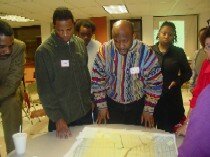
But during our vision session, we found out how difficult it is to build affordable housing. Factors such as density, parking, and costs play an important role. Nevertheless, Our New Community Plan will allow lower-income residents to live alongside higher-income residents; the higher-income residents would subsidize the lower-income residents. The most important element of the Community Plan is that the South Bronx community stays on the Sheridan land and that the South Bronx community benefits from the developments. If the Community Plan is chosen to be built, there will be no chance of a private developer coming in and building a huge strip mall. Although the exact blueprint and management for the residences of the New Community has yet to be determined, our requirements for mixed-unit, mixed-income, affordable housing that reflects the income of the area will remain the same.
Proposed Amount of Housing
The New Community on the Sheridan Plan proposes to build approximately 1,200 new units of housing between Westchester Avenue and E 174th St. All of these buildings would have ground floor retail and commercial space with residences on top. The result is a welcoming shopping experience at street level that provides businesses opportunities and job opportunities. It is also convenient because community residents can find everything they need in their own neighborhood. You can find the New Community Proposed Land and Building Uses here.
Our Housing Proposal not only integrates people of different incomes, but it also accommodates people with different living situations. Our plan is to have one-, two-, and three-bedroom apartments on each floor of the residential buildings. You can find a a rendering of a floor layout here. This mix of incomes and housing reflects the needs of our community, and will strengthen our community.
The Sheridan site has much potential because it is close to public transportation (6 train and many bus lines), the Bronx River, and future parkland that will surround the Bronx River (Concrete Plant Park and Starlight Park). By building responsible housing that reflects the needs of the people living there, we are taking charge of our community’s well-being.
Open space on the site should be developed to integrate with adjoining parkland and streets. Open space will be designed to maximize opportunities for people of all ages and abilities to incorporate physical activity in their daily routine. They will also be designed to maximize access to the Bronx River, not only for residents of the site, but for the surrounding communities as well. — Community Redevelopment Principles

Although the Bronx has the most park acreage of any New York City borough, the South Bronx has the smallest ratio of parks to people. Evenso, there are several new exciting developments in the South Bronx; Barretto Point Park and Riverside Park are finished, and Concrete Plant Park and Starlight Park are to be complete in the near future. The South Bronx Greenway Plan has also outlined a future system of safe pedestrian and bicycle routes in the South Bronx, which would give people an alternative to public transportation and would also provide an opportunity to exercise and get around the neighborhood.
Concrete Plant Park begins just North of the Bruckner Expressway on the West bank of the Bronx River and ends at Westchester Ave. Starlight Park will be between 172nd and 174th St on the West side of the Bronx River. Currently Concrete Plant Park and Starlight Park are isolated from residential communities by Sheridan Expressway. These parks will be beautiful new additions to the South Bronx landscape, but access remains an important issue. What is the purpose of building these parks if no one can get to them?
Using Green Space to Get Around
The Greenway system’s goal is to create safe pedestrian and bicycle routes on popular roads so that people are given the option to walk or bike to work, home, the store, the train, or the waterfront. The South Bronx Greenway plan hopes to build Greenways on Lafayette Avenue, Bruckner Blvd, Hunts Point Ave. and Food Center Drive. Greenways not only create safe paths for people to places, but they also help beautify the streetscape and help the environment by cutting down on our dependence on gasoline. They also give us a safe place to exercise, and Greenway maintenance provides job opportunities.
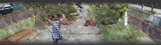
Our New Community Plan includes plans for a new system of Greenways on the West bank of the Bronx River. These Greenways would travel through Concrete Plant Park and connect to the South Bronx Greenway to the South and the Bronx River Greenway to the North. Our plans to create a mixed-use (commercial, retail, and manufacturing) space on the Sheridan land means that people would be able to safely bike or walk to the supermarket, retail shops, friend’s houses, the park, the river, and the 6 train. You can find the transportation plan for the New Sheridan Community here.
Connecting Neighborhoods, Improving Public Health
Public health is a very serious issue in the South Bronx. A recent study also showed that children living by busy highways develop less lung capacity which can lead to respiratory problems for the rest of their lives. This is proved by the statistic that the South Bronx has some of the highest child-asthma rates in the country. One out of four South Bronx children suffer from obesity. The Bronx has the highest rate of diabetes in NYC, and South Bronx residents are 5-8 times more likely to die from diabetes than people living in wealthier neighborhoods.
In our Community Visioning Sessions, residents said that the community desperately needed places to exercise. Exercising fights obesity, asthma, and diabetes, and is necessary to live a healthy and long life. To accomodate the community’s desires, our New Community Plan includes the following:
- Outdoor swimming pool
- Indoor recreational facility
- Soccer field at Starlight Park
- Baseball fields
- Tennis courts
- Concrete Plant Park
- Bike paths that cross the Bronx River, connect to existing bus stops/train stations, and connect to the Bronx River Greenway and the South Bronx Greenway
- Safe pedestrian paths for walking
- Green open space on both sides of the Bronx River
Our plan prioritizes walking and bicycling, and limits vehicle access. Green open space and open facilities would be on both sides of the river, and safe paths crossing the Bronx River would connect the Bronx River and Soundview communities with Crotona Park East and Longwood.
In the South Bronx it is typical to see elementary and middle schools by massive four- to six-lane highways. There are more than 72 elementary, middle, high, charter, and private schools around the Sheridan in Community Boards 2, 3, and 9, and more than half of those schools are elementary and middle schools. The 2000 census stated that 11% of the population in the Sheridan area were over 60 years old and 36% were under 18 years old. Nearly half of our communities is either elderly or young people. It is a top priority to keep our elderly safe and healthy, and to make sure that our young people are healthy and creating long-term healthy habits.
Our New Community Plan provides existing communities places to exercise, play, relax, learn, and grow. Studies have shown that green spaces bring people outside, gets people to exercise, increases self-esteem, betters school performance, reduces crime, and creates a more attractive neighborhood. Along with more exercise spaces, the New Community would offer daycare centers, health centers, an arts center, and other services that a community needs to thrive. The Community Plan’s main overarching goal is to help improve the overall quality of life for South Bronx residents. The legacy of neglect for the South Bronx can be seen in our health, our children’s health, our environment, and our landscape. By pushing to demap the Sheridan, we are taking charge of our public health and quality of life and demanding something better.
Sufficient retail space will be provided to enable residents of the Sheridan footprint and the surrounding community to access a rich variety of high quality goods and services. A strategy must be developed to attract and retain supermarkets, bookstores, and other desired uses, and to support locally-owned enterprises that meet community needs. –Community Redevelopment Principles
Decommissioning the Sheridan Expressway would open up 28 acres of land for development without displacing anyone. Other cities that have decommissioned highways such as Seattle, Boston, and Milwaukee have built residential and mixed-use developments on the “new” land, which has opened up opportunities for economic development and jobs SBRWA hired an independent consultant, SmartMobility, to evaluate the economic impact of our New Community Plan. SmartMobility concluded that although taking down the highway would be costly, the future economic benefits from new business investments and increased spending from people with new salaries would result in a net economic benefit.
How does this work?
Job Creation from Sheridan Redevelopment
| Proposed Sheridan Development | Size | Estimated Jobs* |
| Residential | 1,000 units | 200 |
| Retail | 50,000 sq. ft | 320 |
| Manufacturing | 40,000 sq. ft | 160 |
| Community/Recreation | 30,000 sq. ft | 28 |
| Totals | 700 |
*Employment ratios are estimate from the Urban Land Institute
As a result of our Community Visioning Sessions, SBRWA created the New Community on the SHeridan Plan. The Plan is a set of criteria that SBRWA will follow if the New Community Plan is chosen to be put into action. This criteria includes approximately 1,200 units of housing, 50,000 square feet of retail space, 40,000 square feet of manufacturing space, and 30,000 square feet of community/recreation space. This criteria is realistic to the 28 acres provided, but the exact blueprint of the New Community is still up for design. But using these figures, SmartMobility was able to calculate that approximately 700 new, permanent, full-time jobs would be added if the New Community Plan were chosen!
According to past trends, the Bronx adds about 3,000 new jobs each year. If the Bronx continues to grow at this trend, the 700 new jobs provided by the New Sheridan Community would provide 20% of the expected new jobs for the Bronx! The new commerical/manufacturing space would also provide room for businesses to come in to the neighborhood, providing a much-needed shopping district and on-going economic development.
Here in the Bronx it is critical for us to create economic development and job opportunities for the members of our community. Many people just use the Bronx’s highways and trains to get through the Bronx to jobs that are in Manhattan, Connecticut, or elsewhere. But creating 700 new jobs in the South Bronx would help create new permanent long-time employment and economic benefits for the South Bronx community. And the safe bike and pedestrian routes through the Sheridan Community would connect the area to the larger Greenway system, allowing for people to safely walk or bike to work.